The Prague Post - Hurricane Erin drenches Caribbean islands, threatens US coast

EUR -
AED 4.251215
AFN 76.439115
ALL 96.780134
AMD 443.298699
ANG 2.07205
AOA 1061.502376
ARS 1561.005504
AUD 1.774746
AWG 2.083647
AZN 1.964364
BAM 1.955794
BBD 2.333103
BDT 141.029586
BGN 1.956064
BHD 0.436402
BIF 3413.575239
BMD 1.157582
BND 1.503863
BOB 8.032976
BRL 6.304199
BSD 1.158402
BTN 102.648142
BWP 15.502021
BYN 3.940905
BYR 22688.599422
BZD 2.329703
CAD 1.623954
CDF 3031.128584
CHF 0.93069
CLF 0.02824
CLP 1107.863578
CNY 8.235904
CNH 8.261608
COP 4546.686658
CRC 582.893254
CUC 1.157582
CUP 30.675912
CVE 110.264676
CZK 24.30862
DJF 205.725477
DKK 7.46838
DOP 72.839157
DZD 150.822387
EGP 55.220233
ERN 17.363724
ETB 169.994233
FJD 2.630954
FKP 0.865181
GBP 0.868042
GEL 3.136757
GGP 0.865181
GHS 13.841959
GIP 0.865181
GMD 83.345775
GNF 10051.927086
GTQ 8.872974
GYD 242.349289
HKD 9.005701
HNL 30.422648
HRK 7.535168
HTG 151.568901
HUF 391.866858
IDR 19157.165225
ILS 3.807636
IMP 0.865181
INR 102.640851
IQD 1517.482438
IRR 48690.777358
ISK 141.595476
JEP 0.865181
JMD 186.157846
JOD 0.820692
JPY 176.237159
KES 149.594452
KGS 101.230094
KHR 4656.966219
KMF 491.972438
KPW 1041.81629
KRW 1650.092031
KWD 0.355285
KYD 0.965289
KZT 622.342798
LAK 25142.03482
LBP 103731.543661
LKR 350.490485
LRD 211.980294
LSL 20.057728
LTL 3.418038
LVL 0.700209
LYD 6.297009
MAD 10.611169
MDL 19.605027
MGA 5191.939913
MKD 61.61961
MMK 2430.628466
MNT 4161.4598
MOP 9.278893
MRU 46.264465
MUR 52.435999
MVR 17.722565
MWK 2008.676753
MXN 21.340236
MYR 4.893071
MZN 73.965255
NAD 20.057468
NGN 1691.272546
NIO 42.629691
NOK 11.674791
NPR 164.235099
NZD 2.018896
OMR 0.445084
PAB 1.158397
PEN 3.979671
PGK 4.865944
PHP 67.320898
PKR 327.961854
PLN 4.25957
PYG 8163.011305
QAR 4.235288
RON 5.08753
RSD 117.134529
RUB 93.938139
RWF 1681.380541
SAR 4.341406
SBD 9.527524
SCR 16.497407
SDG 696.288714
SEK 10.995729
SGD 1.502743
SHP 0.868486
SLE 26.85746
SLL 24273.906883
SOS 661.992339
SRD 44.908328
STD 23959.602038
STN 24.499716
SVC 10.135883
SYP 15050.798651
SZL 20.046028
THB 37.655826
TJS 10.639477
TMT 4.051536
TND 3.40579
TOP 2.711169
TRY 48.376041
TTD 7.862909
TWD 35.530001
TZS 2842.915049
UAH 48.222642
UGX 3972.988342
USD 1.157582
UYU 46.419864
UZS 14063.837237
VES 223.480412
VND 30496.487335
VUV 141.009522
WST 3.219934
XAF 655.949409
XAG 0.022258
XAU 0.000282
XCD 3.128422
XCG 2.087676
XDR 0.815791
XOF 655.957908
XPF 119.331742
YER 276.604429
ZAR 20.025768
ZMK 10419.618827
ZMW 26.324036
ZWL 372.740804
  • RBGPF

    0.4500

    76

    +0.59%

  • BCC

    -0.2400

    72.08

    -0.33%

  • CMSC

    0.2600

    23.9

    +1.09%

  • GSK

    0.1500

    43.69

    +0.34%

  • RELX

    0.3100

    45.13

    +0.69%

  • CMSD

    0.1600

    24.3

    +0.66%

  • RYCEF

    -0.1000

    15.1

    -0.66%

  • NGG

    -1.2200

    73.3

    -1.66%

  • RIO

    2.7200

    68.16

    +3.99%

  • SCS

    0.2000

    16.49

    +1.21%

  • JRI

    0.2800

    14.05

    +1.99%

  • AZN

    -0.0200

    84.51

    -0.02%

  • BCE

    0.3000

    24.2

    +1.24%

  • VOD

    -0.1300

    11.17

    -1.16%

  • BTI

    -0.7300

    50.81

    -1.44%

  • BP

    0.2100

    33.7

    +0.62%

Hurricane Erin drenches Caribbean islands, threatens US coast
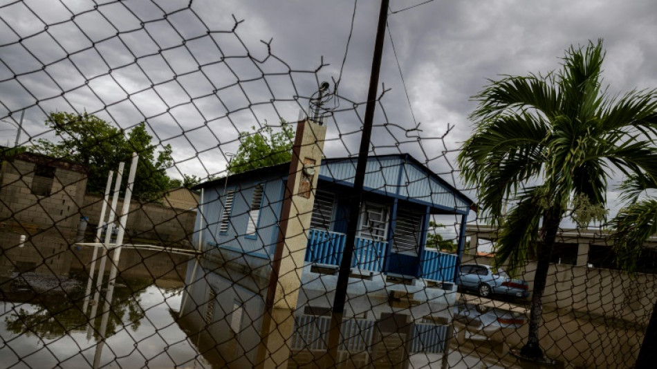
Hurricane Erin drenches Caribbean islands, threatens US coast / Photo: Ricardo ARDUENGO - AFP

Hurricane Erin drenches Caribbean islands, threatens US coast

Hurricane Erin strengthened Monday and was forecast to expand as the powerful Category 4 storm drenched Caribbean islands and threatened dangerous rip currents along the US East Coast.

Text size:

In its latest advisory the US National Hurricane Center (NHC) said Erin was packing maximum sustained winds of 140 miles (220 kilometers) per hour while moving west-northwest at 10 mph.

Its outer bands were forecast to bring localized downpours across Cuba and the Dominican Republic through Monday as well as the Turks and Caicos and the Bahamas -- where a tropical storm warning is in place -- through Tuesday.

These areas could receive localized totals of up to six inches (15 centimeters) of rain, according to the NHC.

In Puerto Rico, a US territory of more than three million people, weekend flooding swamped homes and roads in the island's east, and widespread power outages left residents in the dark, though service has since been restored to more than 96 percent of customers.

Although Erin's core will remain over the Atlantic as it begins curving northeast this week, "Erin is expected to grow rather dramatically in size," warned NHC director Michael Brennan, stressing that peripheral impacts will be significant.

By Tuesday, the entire US East Coast will face a high risk of life-threatening surf and rip currents, which occur when channels of water surge away from the shore.

Coastal flooding, particularly along North Carolina's Outer Banks, is expected to begin Tuesday and peak Wednesday into Thursday, with portions of highway at risk of ocean overwash. Evacuations have been ordered off two islands, Ocracoke and Hatteras.

Wave heights of 20–30 feet (6-9 meters) -- at times exceeding 50 feet -- will create treacherous marine conditions across the western Atlantic.

The Atlantic hurricane season, which runs from June 1 to November 30, has now entered its historical peak.

Despite a relatively quiet start with just four named storms so far, the National Oceanic and Atmospheric Administration (NOAA) continues to forecast an "above-normal" season.

A typical season produces 14 named storms, of which seven become hurricanes and three strengthen into major hurricanes.

This year, tropical activity is expected to be elevated by a combination of warmer-than-average sea-surface temperatures in the tropical Atlantic and Caribbean, along with an active West African monsoon, NOAA said.

Scientists broadly agree that human-driven climate change is amplifying tropical cyclones.

Warmer oceans release more water vapor, fueling stronger winds, while a warmer atmosphere holds more moisture, intensifying rainfall.

Meanwhile, rising seas -- already about a foot higher than a century ago -- mean cyclones are starting from a higher baseline, magnifying storm surges and coastal flooding.

A.Novak--TPP