The Prague Post - North Carolina braces for flooding from 'Enormous' Erin

EUR -
AED 4.277607
AFN 79.892168
ALL 97.082864
AMD 444.357767
ANG 2.084683
AOA 1068.092612
ARS 1514.768735
AUD 1.810221
AWG 2.096875
AZN 2.028967
BAM 1.953416
BBD 2.342941
BDT 141.337531
BGN 1.955099
BHD 0.439092
BIF 3469.666096
BMD 1.164769
BND 1.495575
BOB 8.038191
BRL 6.377697
BSD 1.16328
BTN 101.222482
BWP 15.639915
BYN 3.909929
BYR 22829.466054
BZD 2.333752
CAD 1.616134
CDF 3346.380262
CHF 0.937055
CLF 0.02869
CLP 1125.481268
CNY 8.358613
CNH 8.365858
COP 4690.174029
CRC 587.882629
CUC 1.164769
CUP 30.86637
CVE 110.130612
CZK 24.488128
DJF 207.147226
DKK 7.464281
DOP 72.361236
DZD 151.310805
EGP 56.588422
ERN 17.47153
ETB 165.161374
FJD 2.645481
FKP 0.863293
GBP 0.865435
GEL 3.139029
GGP 0.863293
GHS 12.737457
GIP 0.863293
GMD 83.863364
GNF 10084.650787
GTQ 8.91612
GYD 243.373021
HKD 9.099708
HNL 30.479807
HRK 7.532587
HTG 152.214259
HUF 394.558984
IDR 18965.928355
ILS 3.977009
IMP 0.863293
INR 101.356598
IQD 1523.640758
IRR 48978.523105
ISK 143.406114
JEP 0.863293
JMD 186.372576
JOD 0.82584
JPY 171.7434
KES 150.301483
KGS 101.850056
KHR 4662.310756
KMF 492.118563
KPW 1048.270841
KRW 1627.787622
KWD 0.355988
KYD 0.969367
KZT 626.383381
LAK 25176.474696
LBP 104678.964166
LKR 350.871844
LRD 233.235392
LSL 20.581648
LTL 3.439259
LVL 0.704557
LYD 6.307303
MAD 10.506333
MDL 19.560132
MGA 5128.741588
MKD 61.511958
MMK 2444.50807
MNT 4194.439643
MOP 9.363973
MRU 45.880014
MUR 53.509068
MVR 17.938839
MWK 2017.138561
MXN 21.869352
MYR 4.91999
MZN 74.440287
NAD 20.581144
NGN 1790.436098
NIO 42.807763
NOK 11.929124
NPR 161.956371
NZD 1.999686
OMR 0.44786
PAB 1.16328
PEN 4.088095
PGK 4.82622
PHP 66.51646
PKR 330.080915
PLN 4.248187
PYG 8405.742786
QAR 4.229139
RON 5.054883
RSD 117.181555
RUB 93.766306
RWF 1683.845266
SAR 4.371282
SBD 9.574832
SCR 17.040811
SDG 699.449422
SEK 11.171966
SGD 1.497309
SHP 0.915325
SLE 27.137176
SLL 24424.614392
SOS 664.788783
SRD 44.050433
STD 24108.35994
STN 24.470035
SVC 10.178579
SYP 15144.186867
SZL 20.581206
THB 37.94802
TJS 10.865042
TMT 4.07669
TND 3.3534
TOP 2.728001
TRY 47.660015
TTD 7.891963
TWD 35.287601
TZS 2921.688346
UAH 48.126173
UGX 4146.939644
USD 1.164769
UYU 46.722785
UZS 14559.608203
VES 160.687873
VND 30738.245366
VUV 139.123084
WST 3.12807
XAF 655.157536
XAG 0.030736
XAU 0.000348
XCD 3.147846
XCG 2.096542
XDR 0.814806
XOF 654.599636
XPF 119.331742
YER 279.774376
ZAR 20.600915
ZMK 10484.323374
ZMW 27.156861
ZWL 375.055039
  • RBGPF

    -2.6500

    73.27

    -3.62%

  • CMSC

    0.0500

    23.44

    +0.21%

  • RYCEF

    -0.5500

    13.75

    -4%

  • SCS

    -0.0600

    16.18

    -0.37%

  • NGG

    1.1000

    72.08

    +1.53%

  • GSK

    0.4500

    40.07

    +1.12%

  • RIO

    0.0300

    60.62

    +0.05%

  • CMSD

    0.1000

    23.69

    +0.42%

  • RELX

    0.9000

    48.69

    +1.85%

  • BTI

    1.5400

    59.01

    +2.61%

  • BP

    0.0600

    33.88

    +0.18%

  • JRI

    0.0500

    13.33

    +0.38%

  • VOD

    0.1830

    11.9

    +1.54%

  • BCE

    0.1600

    25.74

    +0.62%

  • BCC

    -3.5600

    84.5

    -4.21%

  • AZN

    0.9800

    80.52

    +1.22%

North Carolina braces for flooding from 'Enormous' Erin
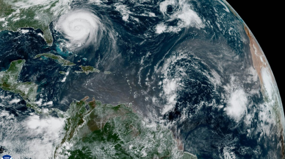
North Carolina braces for flooding from 'Enormous' Erin / Photo: Handout - NOAA/AFP

North Carolina braces for flooding from 'Enormous' Erin

Hurricane Erin was nearing North Carolina's coast Wednesday, threatening huge waves and flooding as the strengthening Category 2 storm triggered mandatory evacuation orders despite its offshore path.

Text size:

The US state, still reeling from last year's deadly Hurricane Helene, declared an emergency Tuesday as Erin's impacts were predicted to begin from Wednesday evening through Thursday.

"Based on the current forecast, we are anticipating coastal flooding from massive waves, tropical storm force winds and tidal and storm surge for much of the state shoreline, especially the Outer Banks, from this evening through Thursday," Governor Josh Stein told reporters.

As of Wednesday afternoon, Erin was churning northward some 300 miles southeast of North Carolina, packing maximum sustained winds of 110 mph (175 kph), according to the National Hurricane Center -- with the possibility it could still restrengthen to a major hurricane.

Its unusually large size means tropical storm-force winds extend hundreds of miles from its center, earning it the moniker "Enormous Erin" by hurricane specialist Michael Lowry, who wrote on Substack the US was fortunate to be spared a direct hit.

Erin's low pressure of around 940 millibars at its center is "remarkably low" and a more telling indicator of its destructive potential than wind speed, Lowry added.

Mandatory evacuation orders were issued for Ocracoke and Hatteras Islands. Parts of North Carolina to Virginia were under a tropical storm warning.

Stein urged residents to pack enough food, water and supplies to last up to five days -- and to safeguard important documents like insurance policies.

"We have already pre-positioned three swift water rescue teams and 200 National Guard troops to various locations on the coast, along with boats, high clearance vehicles and aircraft," he added.

- 'Massive' waves -

Highway 12 -- which runs through the scenic Outer Banks, a string of low-lying islands and spits already under threat from sea-level rise and erosion -- could be left impassable by waves as high as 20 feet (six meters).

Last year's Hurricane Helene caused approximately $60 billion in damage to North Carolina, equivalent to almost two years of the state's budget, said Stein, who criticized what he called inadequate federal assistance from the administration of President Donald Trump.

Trump has mused about dismantling the Federal Emergency Management Agency, which has long been a target of conspiracy theories from the political right.

Beyond the flooding risks in North Carolina, nearly the whole of the US East Coast meanwhile is threatened by rip currents, powerful surges that run against the tide.

- Insurance risks -

The Atlantic hurricane season, which runs from June 1 to November 30, has entered its historical peak.

Despite a relatively quiet start with just four named storms so far, the National Oceanic and Atmospheric Administration continues to forecast an above-normal season.

Scientists say climate change is supercharging tropical cyclones: warmer oceans fuel stronger winds, a warmer atmosphere intensifies rainfall, and higher sea levels magnify storm surge.

There is also some evidence, though less certainty, that climate change is making hurricanes more frequent.

W.Cejka--TPP